Until the middle of the 19th century, most cultivation in India was dependent on uncertain rainfall, and only a few farmers could obtain water by gravity flow through traditional community-managed irrigation sources across minor streams. The maintenance of these traditional sources was transferred from farming communities to the government during the British rule. As these can harness only a small portion of the utilisable surface runoff - estimated at 690 billion cubic meters per annum (bcm/a) - the government has taken up construction of major/medium irrigation projects across rivers to provide canal water by gravity flow to as much arable land as possible, often at high cost.
This raised the net irrigated area under surface water by more than two-fold during five decades, but increasingly this option looks unworkable for the future, as appropriate construction sites for such works are harder to find. Moreover, the displacement and ecological disruption caused by these major projects has turned many communities against them. The proposal to interlink the nation's rivers is thus an unrealistic one, facing practical difficulties as well as significant opposition.
But while tapping more of the surface runoff is problematic, there is an alternative - we must tap more of the runoff that occurs below the surface. This groundwater runoff is estimated to be 432 bcm/a, roughly two-thirds the quantity that is above ground. Groundwater was sparingly harnessed in the past by individual farmers who dug shallow wells to lift water manually or by animal power. With advances in science and technology, mechanised exploitation of deep groundwater has become possible using diesel/electric power for pumping. In the period between 1950-1998, the net area irrigated has increased from 6 million to 12.5 million hectares by shallow wells and from virtually nil to 18.5 million hectares by deep wells.
In the process, India has emerged as the largest user of groundwater in the world. And although the quantum so far harnessed - around 150 bcm/a - accounts for only 35% of the utilisable groundwater, there has been such decline of groundwater levels or depletion of groundwater that it has been felt inadvisable to increase groundwater exploitation any further. But the real flaw arises due to the present practice of extracting groundwater from upland rocky areas through multitude of deep bore wells resulting in local groundwater depletion and steep decline of water levels. The major portion of the unutilised groundwater, which couldn't be extracted by these bore wells, is joining the sandy alluvium beneath the multitude of streams and rivers to finally join the sea. This unutilised groundwater could be easily extracted through wells in the beds of streams and rivers on a sustainable basis without any danger of groundwater depletion.
Groundwater - a practical alternative
We noted earlier that groundwater extraction in non-riverine environments (like urban homes and industrial centres) has dramatically lowered groundwater levels, requiring deeper and deeper wells for future extraction. At deeper levels, groundwater occurs in disconnected fractures within hard rocks, and cannot be easily recharged. This led to a feeling that extraction of too much groundwater should be discouraged. But groundwater in the sandy alluvium in streambeds can be easily extracted in large amounts through infiltration wells and shallow tube wells known as filter points without the massive displacement and ecological changes now caused by surface-level dams. Moreover, in streambeds, near-surface groundwater is plentiful unlike in other areas, and is also replenished must faster than elsewhere with annual floods in the rivers and streams.
Under Indian conditions, there will be 0.6 bcm of groundwater runoff on the average for every bcm of utilisable surface runoff. Most of the surface runoff flows in such a short period under the influence of heavy precipitation and could be used only through construction of huge reservoirs. Groundwater beneath a riverbed, in contrast, flows so slowly and uniformly that most of it could be exploited fairly easily through wells. Construction of subsurface dams across the multitude of streams all along the coastal tracts will prevent substantial fresh groundwater presently joining the sea without at the same time submerging any new land. The water so saved could be diverted into some canal networks for enhancing canal flows. These dams also prevent seawater intrusion along the coast where there is intensive use of groundwater in the streambeds.

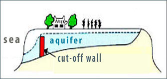
Under the river bed, water seeps through a coarse sandy layer (white) to gather in saturated aquifers (blue). Subsurface flows occur in these aquifers, just above hard rock (impervious layer shown in yellow). The construction of a cut-off wall obstructs this flow, and forces it upward, thus increasing the size of the aquifer.
|
As a subsurface dam only blocks the groundwater that was flowing earlier and any surplus water after saturating the upstream sand freely flows downstream, there will be practically no additional load in the upstream of the subsurface dam. But in the case of conventional dams, the weight of the water column in the reservoir is quite high. As such, the risk of setting off small quakes is much lower for subsurface dams than conventional dams.
Such maximum utilisation of available water through an essentially groundwater-oriented storage and supply mechanism would meet the entire water needs of most river basins without the need to interlink rivers. Measures to enhance recharging of groundwater can also be promoted alongside; indeed. If needed, interlinking rivers can be considered on a small scale in only those places where detailed integrated studies of surface and groundwater resources indicate real water scarcity.