"There can be no substitute for technology if you want to keep track of poverty in a city and provide for the city's betterment, especially the slums", insists Pratima Joshi, director of Shelter Associates. And she should know; the Pune-based NGO she heads has devised a method to employ a Geographical Information System (GIS) in mapping poverty and directing the information thus gathered toward urban development activities. Pratima was recently in Washington DC, at the invitation of the World Bank, to present a paper on this topic at a symposium on Urban Development for Poverty Reduction.
Very often we come across instances in our daily life where the lack of adequate information results in civic chaos and mismanagement. Take rehabilitation work for example. Development projects such as road widening, riverbed work, and construction of bridges leave hundreds displaced. But almost always, the rehabilitation work is haphazard because the civic authorities have little or no clue about the number of people being displaced or the exact number eligible for resettlement. There are other examples too - we come across settlements where the civic body sets up community services like common water posts despite the fact that the inhabitants there have individual tap connections. Fires breaking out in informal settlements claim more victims simply because the affected area is inaccessible to fire engines, and the lanes are not widened because clear geographical details of the area are not available.
All such problems, which eventually lead to wastage of manpower, efforts and resources, arise out of one major cause - the lack of current and comprehensive information about urban areas. And it is this lacuna that Pratima Joshi's team at Shelter Associates (SA) addresses with its use of GIS software.
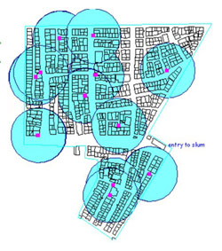
The Gandhinagar slum in Pune. Cyan circles are drawn at a distance of 100 feet around each common water standpost. Magenta rectangles are water standposts. This demonstrates that water to household reach is fairly good. |
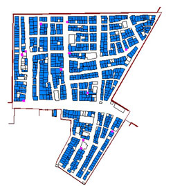
However, all houses in blue have their own individual connections. Although nearly all houses had individual water connections, the Pune Corporation was still installing common water posts in the slum. |
"Infrastructure projects are spatial activities and slum settlements are spatial entities. Hence spatial information is essential", explains Joshi. "GIS is a tool which allows us to use and analyse spatial information in conjunction with relevant socio-economic information, and is therefore an ideal basis for planning", she adds. In addition, this information is intended to create an impact that is best achieved with a visually clear and attractive format, which again the GIS achieves effectively. Explaining the exact process, Joshi says, "GIS integrates spatial information (maps) with any other data you have collected. For example, a typical slum map will show you the physical features of the area, but it does not say anything about the inhabitants and their demographics. So what we do is send out our workers to collect the relevant socio-economic information about the residents and then superimpose all this on the plane-table map that we have scanned".
What's more, the GIS allows you to run queries and make analyses and this is its biggest advantage. Hence, what you have is not just information, but "intelligent information" as Joshi puts it. For example, if you are discussing a resettlement plan, then you can ask queries such as "How many of these residents are on the 1995 electoral list?" Such a query is significant, because according to the law, a slum dweller who is a resident of a settlement prior to 1995 is eligible for resettlement if evicted by a development project. So, by asking such queries, you can actually have the number of people who will need to be resettled and further plans can be drawn up more systematically, finally ensuring the well-being of the poor.
SA's work on GIS arose out of its own experiences in slum development projects. Its workers were confronted with the unavailability of any kind of reliable socio-economic information about the slums they were working in. To counter this problem, in 1994, SA started compiling a database of slums. Its workers and the slum dwellers they trained collected detailed information about each household that they visited. At the end of it, a huge amount of information was in hand, and thus started the task of putting to use the GIS in order to streamline this information and use it intelligently. By 1998, detailed information for 394 slum settlements had been digitalised on the development plan of the city.
SA made this information available to different urban groups, including municipal officers, slum dwellers, ward committees and other citizens so that slums could be included in planning and more accountability could be assured in decision-making. The work received the strong support of Ratnakar Gaikwad, the then Municipal Commissioner of Pune and currently the Commissioner for Co-operation and Registrar, Co-operative Societies, Maharashtra State. "I feel that this project was innovative as urban development, particularly planning for the poor, is often hindered by the lack of information about the city", he says.
The subsequent years saw the interest in this project dwindle as Gaikwad's successors failed to take it up. However, SA has continued with its individual GIS-related projects. In 1997, severe floods hit Pune and slums along the Mula-Mutha rivers in the city were severely affected. At the request of the municipal corporation, SA and community groups surveyed the slum settlements along the river. The settlements were mapped and all the household data were connected to the maps using GIS. The GIS allowed a calculation and visual presentation of exactly how many houses had been fully or partially
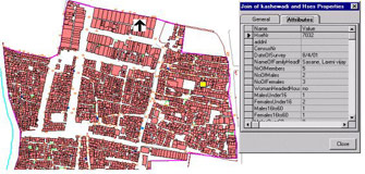
A slum census similar to the one in Pune was initiated in Sangli too and this was better received. Seeing this work done by SA and its associates, a media-urban government-civil society forum organised by the Canadian Institute of Governance decided to locate its India city study in Sangli, instead of Pune as originally planned. Currently the first phase is complete and the proposed second phase of the project will include sharing slum-level information with councillors and community leaders, and developing criteria for selecting slums for preparing community-level action plans. According to Ashwani Kumar, the municipal commissioner of Sangli, the GIS improved the Sangli slum survey through its ability to link spatial and non-spatial data, to combine maps and provide easy access to data. While GIS is an expensive tool, SA believes that such expenses can be borne by local authorities in partnerships with NGOs and community-based organisations. This way, consultancy and training inputs are highly subsidised.
"I feel one major reason for this system to be not taken up is the inherent resistance to technology", says Joshi. "We tried to start a training session for the PMC authorities, but when you have to begin by explaining what a computer and mouse is, the going gets tough". However, the response she got in Washington was overwhelming. While the GIS is not new to some civic authorities who do use it for mapping purposes, such use of technology was novel. "Most of them could not believe that the it could be used thus to effectively map a city's slums and consequently aid development projects with increased transparency", points out Joshi.
She reiterates that the GIS is not merely a mapping system, but a tool to query, analyse, and map data that will lend support to a more effective decision-making process. In her work, the old adage - better information for better decisions - is proven regularly.


