The Mullaperiyar dam in Idukki district of Kerala recently hit the headlines once again as the Supreme Court intervened in the dispute between Kerala and Tamilnadu over increasing the height of the dam. Built in 1895 by the then Madras Government on a lease from the erstwhile Travancore State for 999 years, the dam enables Tamil Nadu to divert 640 million cubic metres of water annually. What could have been the reason - apart from obvious pressure from the British - that had prompted the king of Travancore to lease a dam site of 8100 acres and water for almost a thousand years for a pittance of Rs.5 per acre, and increased to Rs.30 in 1970? The knowledge that Kerala has water in abundance and the firm belief that it would remain so forever.

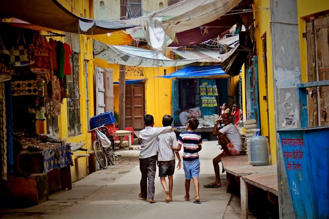
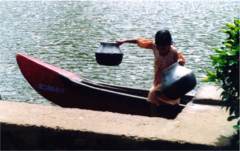
![]() Kuttanad in Alapuzha district. Women on a raft in search of drinking water.
Pic: Quest Features.
Kuttanad in Alapuzha district. Women on a raft in search of drinking water.
Pic: Quest Features.
It's true that with its enchanting greenery and network of backwaters and rivers Kerala is still thought to be a water-plenty state. But despite getting an annual average rainfall of 3000 mm which is 2.5 times higher than the national average and having two monsoons spread over six months, the state has been experiencing water scarcity since 1980. Rivers that were perennial until a few years ago turn into beds of sand during the lean months, and wells dry up before the summer peaks. A casual observer will see many villages and towns depending on tanker lorries peddling water. Two years ago the state government was forced to declare nine out of 14 districts drought-hit. The centre for Water Resources Development and Management (CWRDM) at Kozhikkode has pointed out in a 1992 document that Kerala, which is one of the wettest places in the country, is behind dry Rajasthan's per capita availability of water.
The peculiar slanting topography of the state and the high density of population are highlighted as the main factors for the acute drinking water crisis in the state. The state is a steep narrow strip lying between the Western Ghats and the Arabian Sea and the rainwater finds an easy outlet into the sea within 48 hours of precipitation through the fast-moving monsoon fed rivers. Also, the state has highest density of population in the country870 persons per sq km against the country's average of 324.
Though factors like topography and population density contribute to water scarcity, even the State Water Resources Minister, Thiruvanchoor Radhakrishnan, confesses that it's sheer mismanagement of biodiversity including water resources that has led to the present water crisis in the state. "Besides the natural factors, human induced problems by way of faulty, unscientific land use practices, paddy wetland reclamations, deforestation, sand mining, urbanisation etc have affected water sources of the state," laments the minister in the January issue of 'Kerala Calling', a State government publication. He goes on to underline the need for urgent steps to tackle the crisis.
What does the Minister suggest for overcoming the grim situation? After hammering in some more schemes, he presents a plan for creating awareness among the people about the need for conservation of water: jala yatra (water procession), supplying audio cassettes of jala ganam (water song) and all school children taking the jala pratingnya (water pledge).
Creating awareness is laudable, no doubt; but will it alone create more drops of water? One would think that the Minister would strike hard at the root of the malady.

The 244 km long Periyar river, the longest in the state has a vast watershed, most of which was once dense forest. However, forest cover is available now only for about 500 sq kms. So the river which has a flow rate of 1400 cm to 2000 cm per second during the rainy season has become sluggish in the summer with the flow rate falling to 4 to 17 cm per second. There are as many as 14 dams in the river and this too has contributed to the river becoming lean. The Pampa river, at its upper reaches was charged by 288 rivulets and streams. Many of them have gone dry. The 202 km long Bharathapuzha, the second longest in the state, presents a sad picture. One of its tributaries has dried up completely.
Deforestation has also resulted in soil erosion, which has quickened the runoff, reducing the percolation of water and thus the replenishment of groundwater. Even afforestation attempts by the government have affected the groundwater situation adversely as the majority of trees planted were/are acacia and eucalyptus both of which have deep roots and suck out the groundwater.
River-sand mining is another serious factor contributing to the leaning of rivers. Sand base holds water and that is what makes the rivers 'perennial'. It is estimated that at least two thousand lorry loads of sand is being mined from Bharathapuzha alone, per day. Most of it is illegal. But the sand mining lobby or 'mafia' -- as some people prefer to call it -- is so strong that no amount of public protests has produced positive results. With construction activities in the state on the boom and the demand for river-sand continuing to be very high, the situation is worsening.
With plantations - especially pesticide-needing cardamom - substituting forests, the rivers are polluted at the source itself. The pesticides ultimately reach the water bodies. Multitudes of factories situated on the banks of rivers pump out untreated effluence into these rivers. There are 247 industrial units on the banks of the Periyar. They consume large quantities of water per day and in turn churn out untreated/little treated wastewater into the river.
Minister Radhakrishnan had also referred to the shrinking of paddy fields. Paddy fields are natural rainwater storages. If the average water level in a paddy field is one foot, an acre of the field will be holding 1200 cu ms or 1,200,000 litres of water. This percolates down and replenishes the ground water. In 1970-71, paddy was cultivated in 8.75 lakh hectares, whereas in 2004, it was confined to 2.87 lakh hectares. The damage that has been done to the ecology can be imagined. There is certainly a percentage that has been left fallow by the farmer for financial reasons. But the major contributory factor is the conversion of paddy fields into residential, commercial and industrial areas, according to the Economic Review 2004, published the by the State Planning Board. (1 lakh = 100,000)
![]() Kuttanad in Alapuzha district: a girl scampering to the boat that has brought
drinking water (not seen). Pic: Quest Features.
Kuttanad in Alapuzha district: a girl scampering to the boat that has brought
drinking water (not seen). Pic: Quest Features.
Similar is the story of wetland conservation. India is a signatory of the Ramsar Convention which calls for conservation of internationally important wetlands. The Ashtamudy Lake, Sastamkota Lake and the 96 km long Vembanad Kole Wetland in Kerala had been designated as Ramsar Sites in 2002. However these lakes are highly polluted with industrial effluents, agrochemical residues and sewage. More alarming is the rate at which reclamations take place. Most of it is perpetrated by the government itself for building bunds and approach roads for bridges and even for financing bridges by selling reclaimed land. The state is yet to formulate a wetland conservation policy.
Kerala's geology, physiography, coastal environment and rocky high ranges are not congenial for widespread drilling of tube wells and borewells. Yet indiscriminate tapping of groundwater has been going on unchecked. Most of it is being used for commercial and industrial purposes, depriving drinking water to the neighbourhoods and raising serious questions about the ownership of water.
With 21 reservoirs, the state has one of the highest reservoir densities; one reservoir for every 2000 sq kms. Yet except for four of them all the rest are dedicated for irrigation and for electricity generation; they are not used for augmenting the drinking water system. With a different proportion in the allocation, one could surmise that the drinking water situation would have certainly improved and irrigation would have been affected to some extent, perhaps not alarmingly.
Two monsoons, the South West (SW) and North East (NE) soak the state in water for about six months a year. But according to CWRDM, the high variations in the spatial and temporal rainfall result in the loss of 40 percent of the rainwater through runoff. It has been only a decade since the concept of rainwater harvesting has caught on in the state. The Kerala Municipality Building Rules, 1999 was amended only in 2004 making it mandatory for new residential and other buildings with floor area of 100 sq ms and above to have roof top rain harvesting arrangements. Still, citizens start thinking of water harvesting only when they are acutely affected by water scarcity, for instance, when the KWA supply breaks down or when the wells dry up.
Fresh water availability in Kerala was assessed to be 77.35 billion cubic metres (BCM) by the Public Works Department in 1974. There have not been any studies in this direction during the last 32 years. All planning is being done on those unrealistic data which must have undergone drastic changes due to erratic rainfall, large-scale urbanisation and unscientific land use patterns. The water policy for the state was last formulated in 1992. For the last five years the government has been promising a new water policy, but nothing has materialised till date.
Despite all this, the state government continues to formulate and implement new water supply schemes without confronting the real problems. The Kerala Water Authority had 1855 water supply schemes in operation as of April 2004. There are many other schemes financed by the Housing and Urban Development Corporation (HUDCO), Life Insurance Corporation (LIC) and Japan Bank for International Cooperation (JBIC). Apart from these, there is also 'Jalanidhi', a 2001 state government initiative funded by a World Bank loan. But despite the huge expenditure incurred and debt accumulated, the Kerala Water Authority is able to provide drinking water to only 20.4 percent households in the state, with 71.9 percent depending on wells, according to the Economic Review 2004.
Wells and ponds used to be the primary source of drinking water for the Keralite. But the accent shifted almost overnight, with the entry of the KWA in 1984. The 'treated, purified tap water' became the elixir. Hundreds and thousands of wells and ponds were filled up. The front yard and backyard of houses were re-laid in concrete preventing rainwater from reaching the bowels of the earth. For about two decades at least, a notion prevailed that only piped water is safe, causing incalculable harm to the groundwater recharge capacity. And yet, despite the KWA, Kerala still has the highest well density in the world according to CWRDM.
Subsequently the thinking changed and thousands of wells were dug under the People's Plan from 1999-2000. Many of these wells go dry in summer, as the land does not any more hold the required quantity of water. The People's Plan was a programme of the Left Democratic Front formulated when they came to power in 1997.
Perhaps there is scope for a graph to be drawn. A graph of not how deserts happen, but how 'deserts' are created. Absence of relevant and updated data, lack of long term planning, apathy towards conservation of resources, gradually, but surely leads to total subversion of the natural cycle of water regeneration. (Quest Features & Footage.)