Take a large city with a river running through its length. Allow housing construction in not only low lying areas and pits but also in the river bed itself. Fill up ravines and the river bed with waste and debris. Finally, build an express highway to another large city and construct the canals of a big dam around it. Then let there be a 10-day incessant downpour 50 inches - as never before in the recent history and what you have is a flooded floating city, not a Venice but a calamitous city called Vadodara in Gujarat.
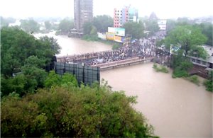
![]() Vishwamitri River in full spate almost touching the Kala Ghoda Bridge. Pic: Divya Bhaskar (DB)
Vishwamitri River in full spate almost touching the Kala Ghoda Bridge. Pic: Divya Bhaskar (DB)
And this could be a perfect recipe for any city in India where indiscriminate "development" is taking place as if land is only a base to bear any kind of construction activity, and as if falling rainwater can automatically find a way out. Says Rohit Prajapati, an activist with the Paryavaran Suraksha Samiti, an environmental NGO based in the state, "Vadodara's town planning has no concept called Water Map that would give an idea about how the water flows. Based on this Water Map, the roads and housing constructions should be given clearances." Instead local authorities turned a blind eye to the construction activities in Vadodara that have obstructed the natural flow of rainwater.
Rishi Shah of ENVIS, a national environmental information system says, "before 1970, there were over 70 tanks and water bodies and today there are only 25." So where will rain water, accumulating and slowly percolating, in these 45-50 land filled tanks would go but spread over the same area and enter the houses constructed on them?
The construction of the express highway passing along Vadodara and Narmada canals around the city had ignored topography and natural rainwater drainages of the region. As a result, the highway on the raised level acted as a virtual dam submerging villages alongside. Also, the Narmada canals stopped water flows on both sides and in many places citizens had to make breaches in the canal to allow accumulated water through. The malaise in planning is exposed completely only when such an abnormal and excessive rain pattern occurs causing untold misery to thousands. In the Vadodara region alone, 25-30 citizens were reportedly drowned while officials estimate 45000 were evacuated in rescue operations.
The worst sufferers in such calamities are often slum dwellers; their hutments at most places bore existence only through their tin roofs peeping above the flood water while many were simply washed away. This time, rich and poor alike lost their homes and belongings.
How the disaster unfolded
• Floods in Sutlej, made in China
• Flood control, Kosi river, Bihar
• Overflowing with the official view
• Monsoon worries in Bangalore
The aerial views telecast and printed in local newspapers, showed ground floors of houses in water and people on upper stories and terraces begging for help. Says Smita Patel, a professor at the city's M S University staying in Siddharth Bungalows, now (in)famous for its wrong planning on the river front, "in minutes water entered our houses and we just watched helplessly as our belongings going under water. The water flowed so strongly that my fridge fell off and floated on water. The society road was like river with gushing water." She adds that on the second day, they received food packets and water pouches airdropped by the helicopter; on the third day, they were rescued by the Navy's boats. "But then there were crocodiles in the water and we just prayed for the end of this ordeal", says Patel.
Unbelievably, some 500 crocodiles had entered the flooded river and many were reportedly caught by the residents in locations along the river. While Siddharth Bungalows came up in an extremely low lying area, the expensive Samarjya Bungalows were built right in the riverbed and were immersed in 6 feet of water. And such stories repeated all over the city. According to one rough estimate mentioned in a local press report, properties worth Rs 350 crore went under water.
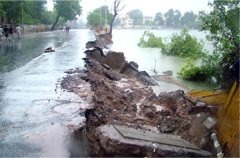
![]() A breach in the centrally located Sursagar Lake - Barodians' favorite evening spot. Pic: DB
A breach in the centrally located Sursagar Lake - Barodians' favorite evening spot. Pic: DB
Yet another factor underpinning the flooding is that Vishwamitri is a narrow and a zigzag river with 178 bends right from its origin in Pavagarh till its confluence with Dhadhar near Jambua. Hence water discharge slows down and flood water does not recede quickly. Besides, like all other south Gujarat rivers, Vishwamitri too runs through alluvial soil. According to a research report "Channel shifting of a highly sinuous meandering river in alluvial plain, Vishwamitri river, Mainland Gujarat" undertaken by the Department of Geology, M S University of Vadodara, the river is shifting eastwards. This process can wipe off all that is along its east bank at some places.
These and other facts about the river must have been known to the planners. But it appears that though information is available in the public domain, planners and decision makers do not seem to bother checking and communicating with the experts. At Gujarat Ecology Commission's (GEC) Environment Information Service Centre which boasted of collecting and disseminating all the information on ecology, officials had no idea about such reports. GEC officials were busy assessing damage to their own property and resources. The Gujarat Disaster Management Cell and its regional units have no full time experts but some officials holding additional charge and have no understanding of disasters, leave alone its management, says Rohit Prajapati.
City has had a better past
Floods are not totally new to Vadodara. The 2005 floods have been assessed as the second worst after the 1927 devastating floods, called Ghoda Poor. The 1927 season witnessed the highest recorded rain levels - 92 inches - and swelled the Vishwamitri so much that flood water had touched the feet of Kala Ghoda statue near the river. Ghoda Poor had wiped off villages after villages and human as well as animal corpses had to be torched on common pyres in mass cremation. While average annual rain received in Vadodara is 30 inches, it was 77 inches in 1878, 69 inches in 1917, and 92 inches in 1927. Also in the last four decades, Vadodara had suffered from floods in 1970, 1974, 1976, 1994 and 1996; but the 2005 floods are comparable only to 1927's Ghoda Poor.
Vadodara city should not have allowed itself to decay especially when it inherits a rare legacy of impeccable administration under the Late Maharaja Sayajirao Gaikwad (1875-1939) the Maratha ruler of Vadodara. The city then maintained good drainage systems through various nalahs and open spaces for natural water flow. Today many of them have vanished under building constructions. The centrally located low lying Dandia Bazar always gets flooded but Maharaja had provided a canal which would quickly drain off the accumulated rainwater. This canal has now become a place for accumulating garbage.
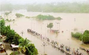
![]() Vadodara 2005 - a floating city. Pic: DB
Vadodara 2005 - a floating city. Pic: DB
An example of Sayajirao's foresight in planning and execution is the Museum in Sayaji Baug, which is hardly 100 meters from the swelling Vishwamitri and yet did not suffer any damage in the current or earlier floods. The reason -- this architectural wonder has a mechanism for draining off the water through channels in its basement out into the adjacent main channel. An administrative block in the city built in 1902 also is a similar wonder. Six lakh rare old documents were saved. Lessons for the city's administrators from such old proven systems exist in the city itself. But city authorities have not learnt from previous disasters. Even the 2005 disaster could be used to learn and plan ahead.
The pity is that a visionary Sayajirao's city has been taken over by greedy politicians, builders and administrators each ever ready to bite off the once beautiful city. Says Ranjitsinh Gaikwad the scion of the royal family and still revered as 'Maharaja' by loyalists, "those days there was a twin drainage system one for sewage and the other for rainwater. Now there is only one drainage line and so even where there was no water logging, sewage water came out of toilet bowls due to backlash of flood water in the recent flood.
Sayajirao had also built both Ajwa and Pratappura dams over 100 years ago with some foresight. Vadodara's lifelines, the Ajwa and Pratappura water reservoirs, have suffered an estimated Rs 56 crore damage due to this unprecedented rain. The Pratappura dam is too old and can breach anytime, anywhere and hence needs complete strengthening and changes in its design, says M K Sinha, director of National Water Commission. After noticing several cracks in Pratappura dam from the devastating Bhuj earthquake (2001), the state government had allotted Rs 7 crore for its strengthening. But corrupt officials have gobbled up the funds, charge the villagers around Pratappura.
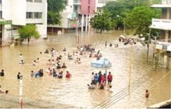
![]() Residential Colonies came up on the landfilled low lying areas. Pic: DB
Residential Colonies came up on the landfilled low lying areas. Pic: DB
According to Narendra Rawat of the Save Baroda Committee, the life of the old Pratappura dam is over and hence it should be written off, otherwise even a greater calamity is waiting to happen. Rawat says the shortfall in water supply can be met through Narmada water. Structural Design expert Dr I I Pandya says that the Pratappura dam structure has got badly eroded exposing the foundation which is a sure shot invitation to future disasters.
Chemical discharge followed the floods
Chemical factories around Vadodara in Nadesari, Ranoli, Manjusar-Savali, Dabhasa, Padra have allegedly discharged their hazardous chemical effluents in flood water to save cost of effluent treatment before sending it to the common effluent treatment plant in their area. During this downpour, a heavy oil slick out of Indian Oil Corporation at Koyli turned a village tank literally into an oil pool from which men and children drew oil in buckets and storing in drums. Cattle died after drinking this oil-rich water.
Around the same time, the compound wall of fertiliser firm Gujarat State Fertilizers & Chemical Ltd (GSFC) near Bajwa was breached to allow water accumulated in the factory premises to flow out. But it suddenly flooded a nearby settlement and forced people to the road. The chemical mix caused them skin irritation and sickness.
The Common Effluent Channel carrying effluents of many factories near Vadodara and passing through villages of Vadodara and Bharuch districts breached at several places and toxic water mixed with flood water spread in farms alongside in villages Dhanora, Sherkhi, Jaspur, Tajpura, Umraya, Akalbara, Dabka, Tithor, Karkhadi, Dudhwada, Kareli, Piludra, Vedach and Sarod. This had already been a longstanding problem causing serious damage to land, crop and groundwater. The current breaches in the channel have compounded this and villagers have demanded immediate closure of the channel. Furthermore, chemicals from Gujarat Alkalies and Indian Petrochemicals Corporation Limited (IPCL) got mixed with flood water and spread in a 20-30 km area. The very fact that the chemical firms are crying hoarse about their loss of raw materials (chemicals) indicates that these hazardous chemicals have got mixed with the rainwater.
The city administration itself is stunned and helpless and citizens are extremely agitated by the officials apathy. Says an angry Lalitaben, a resident of Nizampura which remained inundated even after the rain stopped "not a single official or politician came to help us because who will now allow spoiling starched white clothes with mud and water." Officials were even reluctant to come on the telephone line, people complain vehemently. "These government officials are relaxing like buffaloes in muddy pool. They will only jump out when the relief money comes pouring in" is how another resident Bhaven Kachchi describes the administration. People demonstrated outside the chemical factories and municipal offices at several locations but to no avail. The local press reported that GSFC officials had said that they paid the local corporator (elected representative in the city council) to take care of the people affected by the company's flood water mixed with chemicals but the corporator denied getting this money.
Reversing the misplanning
Post calamity demands are pouring and the authorities have been announcing various measures to avert such disasters in future. Vadodara Municipal Commissioner Rajesh Topno announced that all illegal landfill of the natural drainages, slopes and nalahs which played major role obstructing water flows in the recent havoc caused by the unusual rains will be removed and the authorities have reportedly began the surveys of such illegal landfill. Vadodara's vigilant citizens have time and again, demanded such surveys and ultimate removal of obstructions to water flow but no action was ever taken so far.
Illegal landfilling has been rampant in Subhanpura, High Tension Road, Karelibaug Road, Gotri, Pratapnagar, Makarpura, Ajwa-Waghodia Road, Masiya nalah, Ruparel nalah, Bhukhi nalah and these have been the major ones obstructing the water flow causing flooding of residential areas around them. Even after flood water receded in the river, water is still stagnating in many nalahs confirming obstructions. The aquifers too are saturated so where would the water go? Residents in many buildings have complained of water coming up through the floors and that is causing concern about safety of buildings' foundations. Sama Nizampura areas were getting flooded frequently and hence a satellite survey was ordered to assess the situation. And the demand for removal of obstructions is gaining ground.
But will this undoing be possible? Will it withstand pressures from vested interests? Dr P K Pradhan, chief programme coordinator of Bharatiya Agro Industries Foundation's (BAIF) watershed and rural development work in Gujarat, says, "why should people be allowed to live in the danger zones? If the authority was not aware of the maximum level of extreme flood like this, mark this level now and put a signboard warning people not to inhabit beyond this level mark?" He adds that the government must not provide rescue operation and help if citizens choose to ignore the levels. Prajapati says that administrators need to take hard decisions and relocate the housing colonies.
Some Vadodara corporators are demanding deepening and broadening of Vishwamitri riverbed and not permitting constructions along the river front. Also, for faster discharge of flood water, the river also needs straightening as it runs zigzag. But whether such measures are technically viable or not is not very clear. One thing is clear, though. If there is business for contractors, there may be pocketing of money. Going by the city's recent past, politicians, administrators and contractors may all look forward to this.
Monsoon's upper air cyclonic circulation over Saurashtra & Kutch caused unprecedented heavy rains that resulted into flood situation and inundation of lowlying areas in the state of Gujarat. The situation was critical in the districts of Vadodara, Kheda and Anand while other districts - Surat, Valsad, Navsari, Bharuch, Surendranagar, Dangs, Ahmedabad, Amreli, Bhavnagar, Junagadh, Rajkot, Narmada, Jamnagar, Gandhinagar and Sabarkantha also suffered from the floods. Some 10000 villages in these districts were badly affected.
The cities experiencing severe inundation conditions are Vadodara, Nadiad, Ahmedabad, Navsari, Surat and Limbdi, Dakor, Anand, Kheda, Petlad, Borsad. The rivers reported to be flowing above danger levels are Vishwamitri (Vadodara District) Shedhi and Vatrak (Kheda district). In Bharuch district Vagra, Amod, Jambusar Talukas have been heavily affected. Due to topography and poor drainage of rain water, the river water has changed its course and flooded the villages affecting the roads, power supply other lifeline infrastructures. The small rivulets such as Bhuki Khadi in Amod and Jambusar flowing from Vadodara have overflown inundating roads and villages.
The power supply in 5949 villages and 56 Towns and water supply in 5752 villages and 32 towns have been affected. A total of 132 persons have been reported dead either due to drowning, collapse of building walls. The railway tracks at many low lying stretches have been submerged. Transportation in the affected districts is reported to have slowed down due to closure of 259 state managed road routes, but 95 state road routes remained open for movement. 1239 panchayat managed roads have been closed for movements keeping 302 panchayat roads open for accessibility. The traffic movement on the State Express Highway and NH8 was also affected. The irrigation department has issued high alert for 41 dams in the affected districts.
The state administration has evacuated 500,000 affected persons to safe locations. Some 3 lakh persons have been evacuated from Surendranagar(1900) Bharuch(42717), Kheda(28941), Navsari(33096), Surat(33727), Ahmedabad(5267) and Valsad(3800), Vadodara (99022), Anand (32694), Amreli (11525), Bhavnagar (1216), Gandhinagar (1250), Jamnagar(200), Junagadh(940), Mahesana(230), Panchmahal(51) Sabarkantha(375), Narmada(24) districts. The state deployed 9 army columns in Kheda, Vadodara, Anand, and company of CRPF in Matar and Nadiad with 34 boats have been deployed for rescue operations while 11 Indian Air Force Helicopters have been conducting rescue operations and air dropping of relief materials.
600 trained SRP personnel and State Police force have been deployed. The trained fire bridge rescue teams from all city municipalities are carrying out emergency operations in the affected cities. 200 students from Haryala Gurukul have been shifted to safe place. 400 stranded passengers of Shanti Express at Dakor have been rescued. Power supply has been restored in 5068 villages and 52 towns and water supply has been restored in 3621 villages, and 25 Towns Water is supplied through tankers in Kheda, Anand and Vadodara.


