The Earth has large parts of its surface covered by water. An enormous quantity of water is always circulating along the various paths of the global hydrological cycle. As the basis for all life forms and as the prime mover of human economic activities, water has an overwhelming influence on human futures. The need for an informed approach to this vital natural endowment has been articulated by many (Falkenmark et al., 1980; Wittfogel, 1957). At the global scale, freshwater lakes and rivers, which are the main sources for water consumed by the human societies, contain on an average about 90,000 Billion Cubic Meters (BCM) of water, which is about 0.26 percent of total global freshwater reserves (Shiklomanov, 1993).
With respect to its share of the global water resources, India is regarded as a better endowed country, with an annual precipitation of about 4000 BCM and possessing about 4 percent of the total average annual runoff in the rivers of the world (NCIWRDP, 1999a). Supported by a tropical monsoon climate, the country can be seen to be in a comfortable position in terms of an annual available water resource of 1953 cu km (NCIWRDP, 1999a). On the other hand, it is also true that, if the population of the country grows several times, there will be a proportional reduction in the per capita availability of water. From this point, India is facing a regime of stress (Dyson, 2001), as the per capita availability of water falls down from around 5,177 cu m in 1951 to 1869 cu m in 2001. And given the projected rise in population by the year 2025, the per capita availability is likely to drop to below 1,000 cu m, whence the situation at the country level would be considered as one of water scarcity.
This picture is not unique to India, though its rapid growth in population makes the situation here very dismal. The global withdrawal of freshwater has concurrently increased seven-folds between 1900 and 2000 (Gleick, 2000a). If this trend continues, the world may see more than a six-fold increase in the number of people living in conditions of water stress - from 470 million today to 3 billion in 2025 (Postel, 1999).
1.1 Water Scenario and Issues in India
In terms of the total annual precipitation per unit land surface, India stands well above the global average. However, by hiding the very significant variations in the level of precipitation, the figure of the gross annual precipitation over the country as a whole provide an unrealistic picture of the actual situations with respect to the availability of water prevailing in the various parts of the country, The domination of the Southwest monsoon in the making of the climate of South Asia results in a wide spatial variation in the levels of precipitation from the east to the west (Figure 1) and acute temporal variation through the concentration of heavy precipitation during the 2.5 months of Monsoon period spread over July, August and September. The variability is exemplified by a comparison of the numbers of rainy days in parts of Rajasthan in the Northwestern boundary of India, where it is just 5, and in some areas in the Northeastern India, where it is about 150 (NCIWRDP, 1999a:12).
Similarly, the average annual precipitation ranges from about 200 mm in some locations in the western parts of India to about 11,000 mm in the Northeast. It is quite clear from this, that the averaged out national picture of precipitation is unrealistic. Wide temporal inequity in precipitation, on the other hand, is caused by about 80 percent of the precipitation occurring within a short span of 2.5 months from July to September. Due to this spatial and temporal concentration of rainfall, rivers in some parts of the country experience regular annual Monsoon inundations, often described as flood disasters. On the other hand, areas with lower precipitation are increasingly facing water scarcity, and as conservation measures have dwindled, they become unable to meet the diverse and growing demands of water. Much of this human induced water scarcity is often described as droughts (Bandyopadhyay, 1989).
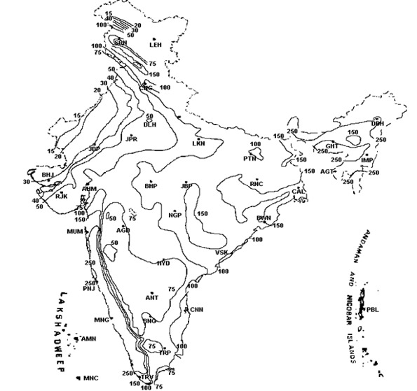
Figure 1: Spatial Variation in Precipitation Pattern over the Country
(Source: http://www.imd.ernet.in/section/climate/annual-rainfall.htm)
2. The Proposal for Interlinking of Rivers in India
The present proposal for interlinking of rivers in India has its conceptual root in similar proposals made earlier. In the nineteenth century, Sir Arthur Cotton proposed such links for promoting inland navigation for better transportation. The idea was later revived in 1972 by Dr. K. L. Rao to address the issue of water scarcity in South India. The Ganga Cauvery Link Canal as purposed by Rao was aimed at both irrigation and power generation (NCIWRDP, 1999a:179-80). In 1977, Captain Dastur, an aircraft pilot, proposed an impressionistic plan for the construction of a pair of canals. Better known as Garland Canal scheme, it envisaged the construction of a 4200-km long Himalayan Canal and 9300 km long Southern Garland canal and the connection between the two systems through two pipelines passing by Delhi and Patna.
On the basis of studies undertaken by the Central Water Commission (CWC) and other experts, these two proposals were not found to be worthy of being developed as a project. In August 1980, the Indian Ministry of Water Resources framed a National Perspective for Water Development and the National Water Development Agency (NWDA) was established in 1982, to carry out studies in the context of the National Perspective. The National Perspective has two main components; the Himalayan rivers development and the Peninsular rivers development.
Under these perspectives, the NWDA took up the task of developing a proposal for inter-basin transfer of water that would be more comprehensive than the earlier ones. The proposals of NWDA for long-distance inter-basin transfers have not been openly articulated so far with any technical details. In fact, it is reportedly still in the stage of an idea, and not a project. The NWDA was to survey and investigate possible storage sites and interconnecting links in order to establish feasibility of proposals forming part of the National Perspective. According to the information available in the Report of the NCIWRDP, the interlinking proposal aims at providing large-scale human-induced connectivity for water flows in almost all parts of India, through a total of 31 links on both the Himalayan and the Peninsular Components (Figure 2). However, the issue gained renewed currency in political, legislative and civil domains after the Supreme Court of India, in connection with a Public Interest Litigation, passed an order on 31 October 2002 for the completion of the interlinking of rivers within a period of 12 years.
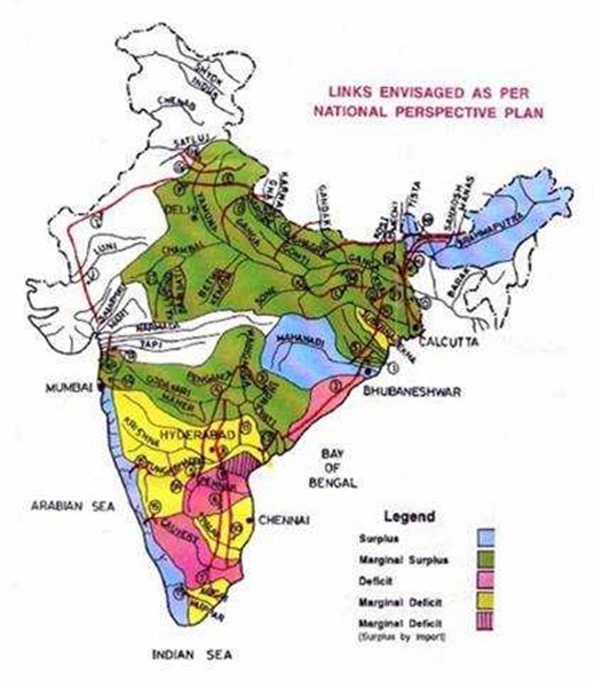
Figure 2: Links Envisaged as per the National Perspective Plan
2.1 Justifications Put Forward for the Interlinking Proposal
The idea of interlinking of the rivers of India is described by - from the President down to local leaders in the less water endowed areas - as the perfect win-win solution for addressing the twin problems of water scarcity in the western and southern parts of the country and the problem of floods in the eastern and northeastern parts. The claims and statements of politicians, do not, however, substitute comprehensive scientific assessment, so that one can know whether by the proposed interlinking, the right quality and quantity of water would be stored and delivered at the right time in the right places and all this would be achieved in the most cost-effective manner. For this, what is needed is sound professional assessment of the technical proposals based on the latest interdisciplinary systems knowledge.
-
There has been no serious attempt to work out a series of area-specific answers by way of local conservation and augmentation to the maximum extent possible. The severe drought of the summer of year 2000 in India was not an indication of water insecurity nor did it point to the need for big projects or long-distance water transfers The drought conditions were a result of bad water management in the past and that the answer lay in better resource management in the future.
In addition, even if the publicized claims of the gains to be made from the interlinking project gets somehow into the public domain, it will be necessary to examine the scientific status of certain concepts that are behind these justifications. It is important to make sure that such a costly project is not based on an outdated and questionable scientific basis. In particular, there is a great need to take into full cognizance, the global move towards a new and interdisciplinary paradigm for understanding and looking at water resources. The interlinking proposal thus, at the start needs to be viewed in the light of the emerging changes in the paradigm of water.
2.2 Changing Paradigm of Water Resource Management
The urgent need for a change in our vision of water has, over the past few years, found frequent expressions in the scientific literature on water and its management. The caution that the 'business as usual' way of looking at this crucial natural resource would lead to severe stress, and probably conflicts, has been registered even at the highest international professional platforms (Anon, 1992:27; Cosgrove and Rijsberman, 2000:xxi). Similar concerns have been expressed in diverse contexts at various points of time by many leading water professionals over the past several years (see for example, Biswas, 1976; Falkenmark et al., 2000; Gleick, 1998; Wolff and Gleick 2002:1-32). While, on the basis of the ground realities, the need for a change in our perceptions about water has been accepted by many, there are yet no common views on the nature and extent of the required changes. The emerging thought is that it is only a fundamental shift away from the present reductionist engineering paradigm to a holistic and interdisciplinary one, which will be able to provide sustainable solutions to the complex challenges facing water management today. These various new ways of looking at water has been commonly identified with Integrated Water Resource Management (IWRM). On the other side, there are those believing in the ability of the present paradigm dominated by supply side solutions, to address these problems, by accepting some adjustments and modifications of the engineering concepts that dominate its practice. Helming and Kuylenstierna (2001) has therefore cautioned that:
-
Tapping into new supply sources tends to either impinge on demands by others, or cause serious damage to nature. Each new source of water is also normally more expensive to develop than the previous one. Demand side management is therefore slowly becoming a new paradigm for water governance.
Twentieth century water resources planning generally relied on linear projections of future populations, per capita demand, agricultural production and levels of economic productivity (Gleick, 2000). The vision of the water resource planners was limited mainly within supply side solutions. However, the professional views of water are changing rapidly, based on the scientific analyses of past mistakes and availability of new information. This changing water paradigm (Gleick, 1998) represents a real shift in the way humans think about water use. For example, In the USA, the country which started the old global trend of building large dams, today there is a new trend to take out or decommission dams that either no longer serve a useful purpose or have caused such egregious ecological impacts so as to warrant removal. Nearly 500 dams in the USA and elsewhere have already been removed and the movement towards river restoration is accelerating (Gleick, 2000). Continued investments in huge engineering interventions is being challenged by those who believe a higher priority should be assigned to projects that meet basic and unmet human needs for water (Gleick, 1996).
Following these paradigmatic shifts in notions worldwide, various other means to conserve water instream is becoming evident. The Murray-Darling Basin Commission in Australia is seriously contemplating on extending financial encouragement to farmers for saving on their allocation of irrigation water and to allow the savings to remain instream. In another instance, Chiles National Water Code of 1981 established a system of water rights that are transferable and independent of land use and ownership. The most frequent transaction in Chiles water markets is the renting of water between neighbouring farmers with different water requirements (Gazmuri, 1992). In the Indian context, Bandyopadhyay (2004), in his assessment of the new National Water Policy 2002 finds that the old paradigm is still strongly entrenched in the official water administration.
2.3 The Reductionist Concept of Surplus River Basins
The proposal for interlinking of rivers is critically dependent on the identification of some river basins or sub-basins as 'surplus' ones, from which water may be transferred to the 'deficit' river basins, as a win-win solution. This is projected as a permanent solution to the problem of human sufferings from water scarcity and floods. The interlinking of rivers is seen as a win-win solution because it will put to use the water otherwise going waste in the surplus river basins (NCIWRDP, 1999a: 181). Prabhu (2003) makes a more direct statement in this regard when he claims, the (interlinking) project is about rationalisation of water that is lost to the sea.
The traditional engineering concepts of water have mainly taken into consideration, visible and flowing water. Indirect ecosystem services provided by water, for instance in the conservation of biodiversity, or its role as a mobile solvent, and many others, have been neglected for a long time (Falkenmark and Folke, 2002). As a result, the reductionist view of engineering is unable to recognise and record the ecological significance of the unhindered flows in the river as critical to drainage, transportation of sediments, recharge of groundwater, maintenance of the delta and highly productive estuarine ecosystems and related biodiversity. Hence, it finds little difficulty in locating surplus river basins, and on that retrogative concept declares that:
-
creation of storages and interbasin transfers from the surmised surplus river basins to deficit basins has been the guiding objective it is considered imperative that all the rivers in the country be linked by a national grid to meet the shortages in the various parts of the country.
The methodology for working out whether a river basin has any 'surplus' water or not, as recommended in the Report of the Working Group on Interbasin Transfer of Water (NCIWRDP, 1999b) of the Ministry of Water Resources, surprisingly, is based on an unpublished paper by Mohile (1998). The scientific status of an unpublished document is surely not an established one, as far the open community of scientific professionals is concerned. In following this approach, a simple exercise in arithmetic hydrology has been employed, that appears to be either not informed of, or ignores the whole set of ecosystem services provided by water. Whilst the process for the assessment of irrigation, domestic and industrial needs have been dealt with in the Report of the Working Group (NCIWRDP, 1999b:30), there is no information given on how the assessment of the environmental water needs for salinity control or other water needs for the continuation of diverse ecosystems services provided by water in the various parts of the basin, would be made. In a well known exercise, but informed of the ecosystems services, Costanza et al. (1997) have estimated that the value of the worlds ecosystem services could be almost twice as large as the global gross national product (USD 33 trillion per year as compared to about USD 18 trillion per year). In this regard, Vaidyanathan (2003) rightly argues that simply identifying a river basin on the volume of flood flows is a misleading basis for judging surpluses. Bandyopadhyay and Perveen (2003) have described such a reductionist and mechanical viewpoint of water in a river basin as arithmetical hydrology.
-
There really seems to be no convincing argument or vital national interest, which can justify this mammoth undertaking (interlinking), in its entirety.
The fact that all river basins have evolved over the geological past by optimising the use of the available water resources and there is no surplus in nature, is not understood from the reductionist viewpoint. As a result, it is convenient for this viewpoint to ignore the totality and the fact that all drops of water in all river basins at all times are performing one ecosystem service or the other. As a result, any transfer of water from one basin to another is not a simple arithmetic exercise. There are diverse social, economic and ecological impacts of all transfers from one basin to another that need to be assessed. Further, those affected socially or economically by the negative aspects of such impacts, should be fully compensated for. In the openly available information on the proposal for interlinking, there is no reference to the assessment of such costs. It is apparent that there are many important reasons for examining the scientific validity of the justifications put forward for this very costly project. For doing this in a fully professional manner, the civil society in the country, however, is dependent on the MOWR making available in the public domain, all the pre-feasibility, feasibility and the detailed project reports regarding the interlinking proposal. Since the prospects of that are remote, in this study, the Report of the NCIWRDP (1999a) will be used as an alternate source of information.