On 5 May 2015, the Central Government introduced the National Waterways Bill in Parliament. The main purpose of the Bill is to declare 101 stretches of rivers in the country as National Waterways. In the Statements of Objects and Reason, the Government states that : “In many countries, the inland water transport is recognised as fuel efficient, cost-effective and environment friendly mode of transport… Yet, when compared to road and rail sectors, required investment has not been made by the Government so far on the preservation and development of inland waterways mode of transportation in the country.”
Considering that till date, we have had only five “national” waterways, each being declared so under its own special Act of Parliament, the intention to go for 101 new waterways indicates a hugely ambitious programme.
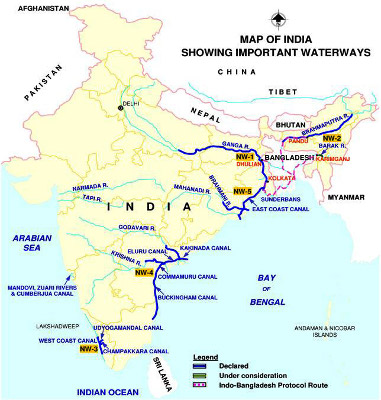
Map showing some important national waterways. Pic: iwai.gov.in/map.php?lang=1
National Waterways
River and canals have been used for transport and navigation since time immemorial in the country. At times, the Government has also undertaken systematic development of these. In the Constitution, inland waterways figure in all three lists – State, Concurrent and Central – of the Seventh Schedule.
By default, it is the responsibility and power of the state government to develop and regulate inland waterways. But as per Entry 24 of List 1 of the Constitution, the Central Government has powers related to “Shipping and navigation on inland waterways, declared by Parliament by law to be national waterways, as regards mechanically propelled vessels; the rule of the road on such waterways.” Thus, the Parliament has to explicitly declare a waterway as “national” following which its development – as regards mechanically propelled vessels – comes under the purview of the Central Government.
The first such waterway to be declared “national” was the Allahabad to Haldia stretch of the Ganga – Bhagirathi-Hoogly in 1986. This National Waterway (NWW) 1 is 1620 km long. NWW 2 – along the Brahmaputra – was declared in 1988, the West Coast Canal was declared NWW 3 in 1993, and NWW4 and NWW 5 - Kakinada- Puducherry canals along with Godavari and Krishna rivers (1078 km) and East Coast Canal integrated with Brahmani river and Mahanadi delta rivers (588 km) were so declared in 2008. Yet, only the first three have seen some development.
The Inland Water Transport policy was formulated by the Central Government in 2001. As per this policy, at that time, the annual cargo movement along inland waterways was a mere 1.5 billion tonne-km (btkm) out of total cargo movement of 900 to 1000 btkm. Interestingly, even in 2013-14, the total cargo movement (in the five national waterways) had gone up to only 2.52 btkm.
Given the slow pace of developments so far, the government’s intention of developing 101 new national waterways seems even more ambitious.
Bigger plans
However, the scope of the plans is much beyond these 106 NWW (5 earlier ones and 101 new ones). First, there is a plan to link many of the national waterways to each other, to roads and railways and to major ports. This scheme is being called the Integrated National Waterways Transportation Grid.
Second, the government has initiated two equally ambitious projects of Dedicated (Rail) Freight Corridors. Along with railway lines exclusively for freight, these corridors will also have multi-modal logistics parks. The corridors will have two components – the Eastern Corridor, running 1839 kms from Ludhiana to Dankuni in West Bengal, and the western one running 1483 kms from Jawaharlal Nehru Port Trust(JNPT) in Maharashtra to Dadri in UP. The Western Corridor will also form the heart of the controversial Delhi Mumbai Industrial Corridor (DMIC).
There are plans to connect the NWW 1 with the Eastern Freight Corridor at several points to allow transfer from water transport to rail and road transport and vice versa. Already, a major hub is being planned near Varanasi. It will be “a multimodal inland water terminal at Ramnagar, on the river Ganga in Varanasi district in Uttar Pradesh… also (to be) connected to the DFC corridor.” The terminal is expected to handle a cargo of 60,000 tonnes per day by 2038.
Many advantages
Two major benefits of water-based transport are being put forward to justify these massive efforts. As the Waterways Bill 2015 states, inland water transport “reduces time, cost of transportation of goods and cargo, as well as congestion and accidents on highways.” Moreover, the government sees this as an area with great potential that is as yet underdeveloped, and hence one that can be used to propel the economy. It expects that the waterways program will draw significant private investment and create a large number of jobs.
Undoubtedly, there are many advantages that water-based transport, particularly inland water transport has. Yet, these advantages are neither unqualified nor automatic. They will manifest only when certain conditions are met, and only under certain circumstances.
Moreover, the extent of the advantage offered will vary from one case to the other, and hence, advantages may not always outweigh the cost. Thus, whether any particular waterway is the optimal choice will depend on the details of the case. Unfortunately, there are no studies of most of the proposed national waterways.
Sketchy schemes, several costs
The Waterways Bill itself points out that “The extent of development, the prioritisation of inland waterways for development and related matters shall be finalised after carrying out necessary techno-economic feasibility studies through Inland Waterways Authority of India consequent upon enactment of the National Waterways Bill, 2015.”
In other words, there have been no techno-economic feasibility studies so far, let alone environmental and social impact assessments, of the 101 waterways included in the Bill. This is problematic, because on one hand, there are very high costs of creating and maintaining the waterways. These costs could be categorised as financial as well as socio-environmental costs. Second, there is a fair bit of uncertainty regarding the exact benefits from these projects. Hence, feasibility and desirability of many of the waterways can be doubtful.
The Inland Water Transport Policy acknowledged the many problems associated with converting rivers into waterways, saying “Most of the waterways suffer from … shallow waters and narrow width of the channel during dry weather, siltation, bank erosion, absence of infrastructure facilities like terminals and inadequacy of navigational aids.”
The financial, social and environmental costs are the result of the fact that overcoming these problems and converting rivers into waterways to make most rivers navigable throughout the year for heavy and large vessels will require massive dredging, massive river training work, construction of barrages, locks and gates and terminals and other facilities. All these have huge impact.
This is also clear from the many objections and apprehensions which various states put on record, when their opinion was solicited by the Parliamentary committee which examined the Bill, and tabled its report in Parliament on 12 August 2015.
For example, Kerala has objected to the declaration of 10 rivers in the state as waterways. The reasons given by the state are that these rivers already have many structures on them like dams, water intakes, bridges etc. It will be impractical to modify all of these. Moreover, dredging of the rivers will lead to large scale sea water ingress, harming the drinking water schemes drawing water from these rivers. They have also expressed apprehension that fish breeding will be affected, impacting fisherfolk.
Indeed, the apprehensions expressed by Kerala are likely to be felt in all the rivers in the estuarine and coastal areas. Since many of the waterways are near the coast, or stretch to estuaries, and many will involve linking waterways with ports, the dangers of sea water ingress and impacts on fish are likely to be felt on a large scale.
Bihar on the other hand has objected to the construction of any barrages (on the Ganga, and other rivers) to achieve the required water depths for the waterways. Apart from dredging, construction of barrages, dams, gates and locks are the other means to achieve the required water depths in rivers.
It may be recollected that when expansion of the Ganga waterway was announced by the Central Government last year (2014), they had also announced that this would be achieved by construction of barrages on the Ganga every 100 km. These barrages would turn the Ganga into a series of still-water reservoirs. There have been strong objections to this proposal, from many local communities, experts and even the Bihar state government.
One basis for this opposition has been the impacts of the Farakka barrage. The Farakka barrage has had severe impact downstream and upstream, resulting in river bank erosion, fears of the river bypassing and outflanking the barrage. The Bihar Government, in its submission to the Parliamentary committee has explicitly mentioned the adverse impacts of the Farakka barrage to argue against any barrages on the waterways.
Operational impact
While even official reports acknowledge the impact of dredging and barrages, there is little attention paid to the impact created by the operation of the waterways. One of the issues is the contamination of water due to mechanical vessels running on oil. This is likely to have serious repercussions on fish and other aquatic flora-fauna.
Professor Bharat Jhunjhunwala, an economist who has studied the issue extensively, points out in a booklet the impact that the Ganga waterways will have on the Gangatic Dolphin, which is a keystone species in the Ganga. "Moving of ships will create turbulence and pollution. The dolphin is a blind animal which navigates the waters and closes in on its prey using sound to locate objects. The noise from ships will create disturbance to the dolphins’ ability to sense and navigate,” he writes.
Another issue is the impact of the cargo. One of the major components of cargo will be coal – with imported coal being taken from ports, domestic coals being taken from coal mines and transported to thermal power plants inland. The ships are also expected to transport back the fly ash generated.
For example, the NWW 5 is expected to transport 10 million tons of coal annually. NWW 1 (Ganga) has already been targeted for the transport of 3 million tons of coal, and more in the future. Equally important, the Eastern Freight Corridor is planned so as to transport 62 million tons of coal by 2021-22. Thus there will be significant transfer of coal between the waterways and the freight corridor. Coal transport - and particularly the hubs, handling and transfer points, terminals have serious impact on the surrounding areas due to coal dust.
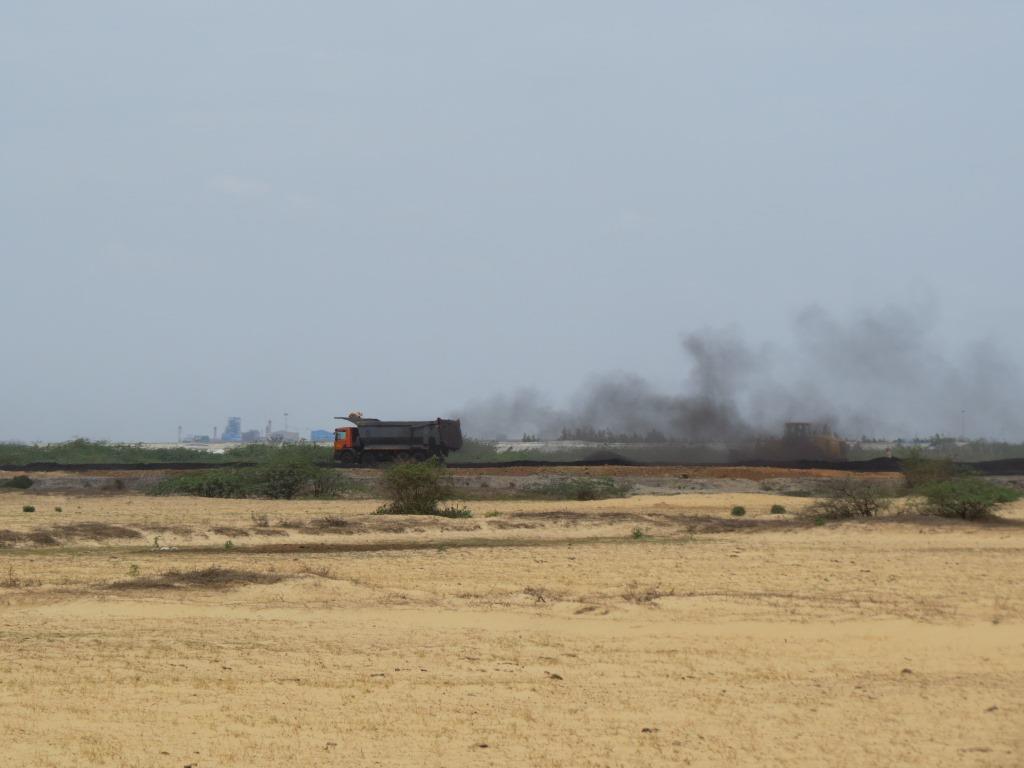
Coal Dust emitted during coal handling at Krishnapattanam port. Pic: Shripad Dharmadhikary
For example, in recent years, the handling and storage of coal at Mumbai’s Haji Bunder (port) has been in the news due to its serious impact on the surrounding communities, where coal dust has polluted both air and water. The pollution control board’s regional officer even recommended shifting the coal handling from there, whereas the waterways plans are in fact proposing many such new hubs.
In a visit by this author to Krishnapattanam port in Andhra Pradesh, villages several kilometres away were also found to be affected severely by coal dust. Coal dust not only pollutes air, but also has significant impact on water. Coal dust in water can harm aquatic life by creating turbidity, through chemical impacts on ingestion, and abrasion effects on the sensitive gills of fish. These impacts are likely to be huge as coal is likely to be a major cargo.
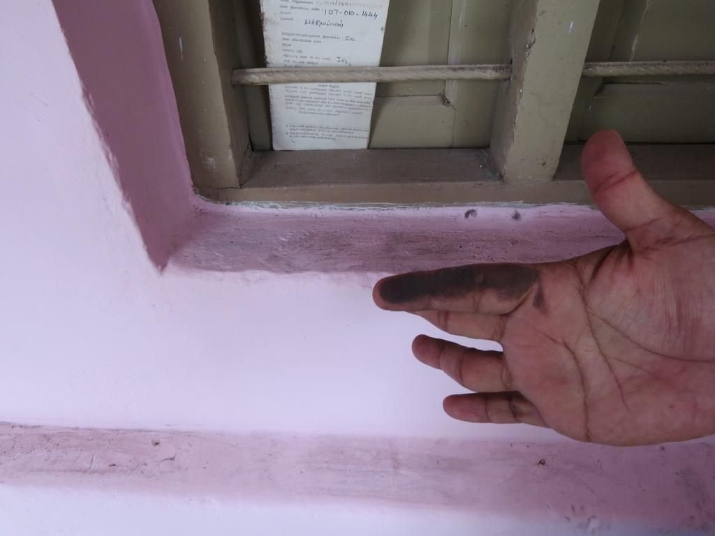
Coal dust accumulating on a window sill in a house next to railway coal handling yard. Pic: Shripad Dharmadhikary
Similarly, another significant cargo item will be Petroleum, Oil and Lubricants (POL) products. One can imagine the impact in case of any accidental spill in the waterway.
The Inland Waterways Authority of India (IWAI) acknowledges some of these risks when it tells the Parliamentary committee that “…there are two issues in the transportation through inland waterways which have now actually started getting developed and used. One is …when the dredging is done, or when the vessels are moving, its effects on the banks, on the fishers, etc should be considered. The second is related to cargo and vessel, which cargo is being moved, which vessels are being used, whether they are equipped adequately and whether they are environment-friendly or not.”
But little is being done to assess these impacts.
Will advantages outweigh costs?
NTPC, which is currently using the NWW 1 to transport coal to its power plant, told the Parliamentary committee that “the transport cost through waterway is only slightly lesser compared to the railways right now, since the cargo is transported one way only.” This means that unless a return cargo can always be ensured, waterways may not offer a large cost advantage.
The IWAI is more specific. It has submitted to the Parliamentary committee that with regard to cost, it is understood that it is marginally lower by 10 per cent or so in the case of Farakka. But as far as a general comparison between waterways and road or rail is concerned, the cost varies from one waterway to the other. For example, if the waterway’s depth is only one metre, then inland waterways will not be cheaper. However, if the waterways is well developed, and 2.5 to 3.5 or 4.5 metres in depth, then the cost of transporting could be almost 60-70 percent of Railways, or even less than that. But it will not necessarily be so much lower in every case.

This means that the cost advantage is not always a given, it would depend on the specifics of each case. Moreover, the cost advantage seems to come in only when the depth is developed to 2.5 or 3.5 or even 4.5 meters, which is significant, and will entail very heavy financial and environmental costs of dredging etc. In that case, it’s a moot question whether the 30-40 percent advantage over railways would be worth it.
Even the macro picture does not reflect great advantages. The 2001 Inland Water Policy noted that “The potential of cargo movement by the declared National Waterways and other waterways is estimated to be 50 billion tonne kilometres.” Considering that the total cargo movement at that time itself was around 1000 billion tkm, the total potential of waterways was only around 5 percent.
Moreover, the policy noted that a shift of one billion tkm to IWT will reduce the fuel cost by about Rs. 25 crore and the cost of transportation by about Rs. 45 crore. That is, the maximum savings in the cost of transportation would be around Rs. 2250 crore per year (Rs. 45 crore per 1 billion tkm times 50 billion tkm).
This too would apply when the shift is from road and not from rail. Is this saving so large, particularly considering the thousands of crores of rupees of investment required and the huge social and environmental costs that will be incurred, virtually reducing our rivers to mere canals and channels?
It’s true that these figures pertain to 2001, so there is a need to look at these figures afresh. But that is not being done either. The advantages of waterways are being taken as “given”.
In conclusion, we are not against development and use of waterways, particularly if they offer real benefits. But these benefits should be realistically and credibly assessed first. In fact, we would agree with Professor Jhunjhunwala, who recommends that given the clear extent of the costs involved, it may be much better to explore options to develop waterways in rivers using only the natural flow of the river, what he calls “non-intrusive alternatives”.


