Shashank Menon works in an IT company in the periphery of Bangalore. He stays in an apartment complex 2 km away from his workplace. He takes his vehicle to work because there is no place to walk on the streets and crossing the big wide signal-free corridor is a nightmare.
A vegetable vendor in Bangalore, evicted to the periphery of the city, has to travel to the city at 5 am every morning on his petrol-run two-wheeler. He could have saved more than half the money he spends on commute if he used a bus, but he would lose business if he reaches the market late. A slum dweller in the centre of the city also has to either take an auto to reach the nearest bus stop, which charges Rs 30, or walk to the nearest bus stop more than 2 km away.
It is apparent that the availability of reliable, safe and accessible commuting facilities in the city has left much to be desired. The same may be said of delivery of other basic services such as water supply, sewerage connections and treatment, solid waste management, etc. However, Bangalore like many other cities has no dearth of well-documented plans, studies, policies and regulations.
The problem is that the plans for Bangalore talk about each other, but do not talk to each other. Consequently, the investment decisions are not in sync with the ecological resource realities, and the desired population distribution strategy remains unachieved. This, in turn, creates an unplanned requirement of infrastructure and services.
The assortment of plans, their agendas and their focus is confusing for decision makers as well as citizens. However, as spelt out in the visions and statements of objectives of these plans, they all aim for inclusiveness, increasing accessibility to quality services, propelling economic growth, enhancing liveability and bringing in good governance in a sustainable manner.
There is a lot of debate on the simultaneous existence and functioning of so many plans. The need for a tool to regulate and manage present developments while planning and accommodating future growth is imperative. But to ensure that tangible benefits emerge from this planning process, the plans need to fit or align with each other.
This means that the plans need to be spatially dovetailed, synchronised in time horizon and convergent in their strategies with complementary proposals and consistent policies.
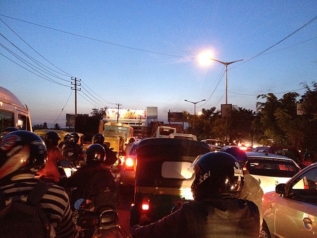
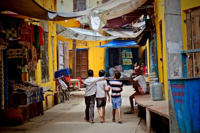
Evening traffic at a signal in Bangalore. Pic: Subhashish Panigrahi/Wikimedia
The myriad plans for Bangalore
The Master Plan for Bangalore is going to be renewed with an eye on 2031. The Bangalore Development Authority (BDA) had initiated the tendering process in 2012 and actual revision work is expected to start soon. The Master Plan is a statutory document mandated by the Karnataka Town and Country Planning Act (KTCP Act 1961), and indicates how and where the city will develop.
The Master Plan jurisdiction covers an area of 1306 sq. km which is termed as the Bangalore Metropolitan Area. It essentially determines the blueprint for horizontal and vertical growth of the city which is revised every 10 years.
For the common citizen, the Master Plan addresses the following: whether one can build on his/her land, convert the existing property, and how much may be built upon and for what purpose. These are essentially guided by the Proposed Land Use (PLU) and the Development Control Regulations (DCR) framed within the Master Plan.
To grant permission for the above is the routine work of corporations. However, the permissions should ideally entail assessment of the development impact on water, power, sanitation services and most importantly connectivity. Differential land use, with varying densities, implies different rates of attraction of people and services and that in turn impacts land value and property prices, environment and resources, etc. The cycle continues, propelling the growth or decline of an area, as the case may be. There are varying degrees of economic, social and physical impact of land development, often more than what is addressed in the Master Plan.
The Structure Plan (SP) prepared by the Bangalore Metropolitan Region Development Authority (BMRDA) is again a strategic guiding document for a larger region around Bangalore (spread over 8005 sq. km) called the Bangalore Metropolitan Region (BMR).
There are also other plans such as the City Development Plan (CDP), Comprehensive Traffic and Transport Study (CTTS), plan for the once proposed IT Corridor and so on. All these plans follow different jurisdictions such as the Bruhat Bangalore Mahanagar Palike (BBMP) area for CDP, or the BMR (under Bangalore BMRDA) for the SP and CTTS.
Moreover, departments and authorities responsible for providing a range of infrastructure and services such as water, sewerage, transport and mobility systems, power, etc. have their respective sector plans and policies. Many of these have not been dovetailed in space, the strategies are not really converging, if not actually conflicting; thus projects that have emerged have been inconsistent and ultimately ineffective to a large extent.
Land use and transport integration
Consider, for example, the growing concern over daily commute in the city, which entails travel time penalty of 60 percent or more during peak hours. The Revised Master Plan (RMP) for 2031 will hopefully have ‘sustainable urban mobility integrated with land use’ as one of its agendas, as mandated by the National Urban Transport Policy (NUTP). The NUTP is a well-intended policy document, focussing on land use and transport integration. But how can that be done?

The draft CTTS for BMR and the draft revised SP for BMR were fortunately initiated by the same authority, have the same horizon period (2031) and were prepared in tandem. The strategies and proposals in these two plans are thus substantially aligned to each other. However, there is no existence of a mobility plan at the city level aligned to the proposed land use.
The Master Plan will surely propose roads and other transport linkages with indicative alignment and share of land use under transportation as specified by current norms and standards. But it can hardly do enough justice to meaningful land use and a mobility integration plan within its scope.
The idea of land use and mobility integration strategy can be taken forward by the initiation of Comprehensive Mobility Plans (CMP) for cities. The ultimate objective of a CMP is to provide a long-term strategy for the desirable mobility pattern of a city. A CMP is to be based on a holistic approach, linking the long term visions, goals and objectives of the city to the mobility plan. It focuses on integration of land use, a public transit strategy integrating pedestrian and other non-motorized modes, demand management, cleaner vehicles and enhancement of capacity and awareness; with stakeholder engagement and participation must be a key element in this entire process.
A CMP can thus be designed as a strategic document focusing on the mobility of people rather than vehicles. This calls for a paradigm shift in approaching urban transport issues.
To explain further, conventional studies such as the CTTS assume a steady rate of growth of vehicles and propose increased supply of infrastructure to accommodate the same. A CTTS has neither the mandate to look at land use patterns in the city and align its proposals accordingly, nor does it push for strategies that encourage less motorised trips, shift to public transport and moving towards cleaner fuel and efficient transport options. However, a CMP can or ideally should do so, empowered by the NUTP.
It thus becomes imperative that the land use plan (Master Plan) and the mobility plan (CMP) be prepared simultaneously so that in the end the proposals are consistent with each other.
But how do we ensure that different plans for a city are in alignment and can finally lead to a common positive end, even if the implementing authorities are different? The answer is short: Creation of a conducive platform to talk and carefully synchronise the process of interaction among all.
Can we then have citizens’ representatives, industry, transport operators, members of academia, policy makers, think tanks, lawyers, urban and transport planners and designers, as well as other stakeholders come together on a common platform to review the blueprint for Bangalore and ensure that it is consistent with other plans?
This needs strong will and a thoughtfully designed programme for participatory planning. There are ample case studies from India and South Asia that demonstrate the success of participatory planning and monitoring, such as the citizen-led monitoring of water and sanitation in the three cities of Raipur, Ranchi and Varanasi of India or civic participation in budget preparation and monitoring in Madhainagar of Bangladesh, to cite a couple.
There are bound to be challenges including weak political engagement, absence of intensive capacity building programmes and need-based training for citizens, stakeholders and even the marginalised on the development of the master plans. Nevertheless, it can be a pioneering exercise and surely merits an attempt.